Getting Started with Shore Diving in the NYC Area
INTRODUCTION
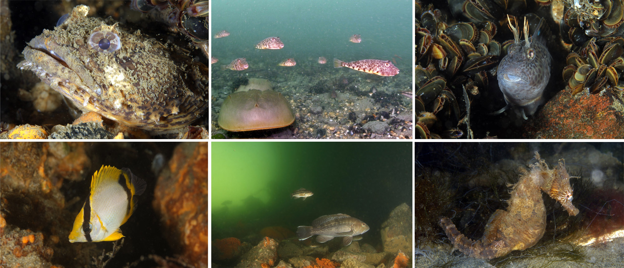
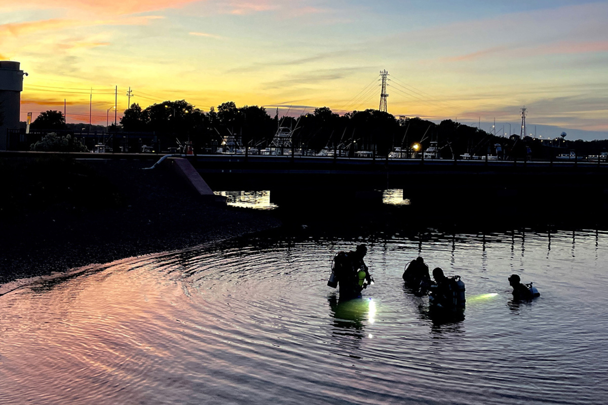
Our dive club has a number of resources about diving in the New York City area, including a guide for people just getting started, focused on boat diving and the offshore wrecks. This article is about shore diving in our area. Check out the gallery below for some photos, as well as a video at the bottom of the page showing what diving is like at the Manasquan River railroad bridge. And feel free to get in touch if you have specific questions!
- Michael Rothschild (New Jersey dives, underwater images and video)
- Harris Moore (Ponquogue Bridge and Beach 8th Street dives)
- Special Thanks to Bill Cadden, Adam Schneider and Meredith Massey
LOADING

SHORE DIVING
Our charter boat dive trips are amazing, with many historic shipwrecks to explore. And while these dives are deeper with typically better visibility, larger sea life and often fascinating back stories, shore diving has a number of advantages over boat diving.
First of all, once you have your gear, shore diving is very cheap – the cost of an air fill – while charter spots are usually $100-$200. Also, you are not dependent on anyone else’s schedule, only the tides determine when you can dive. The boats stop going out in the off season (December – April), but the ocean is always there. There are no issues with sea sickness, and no cancelled dives due to big waves.
The shallow water is usually warmer as well. While I always wear my dry suit for boat dives, I dive my 5mm wetsuit year-round off the shore. A boat dive typically takes up at least half of a day, requiring you to be at the dock before 6 AM, and not returning until the afternoon. Shore diving can be done in an hour, with plenty of time to enjoy other topside activities with your non-diving friends and family.
Night diving is an incredible experience - animals that hide during the day are out and about after sunset. Bioluminescence is also amazing, and I have seen this in New Jersey. The charter boats very rarely do night dives, but when high slack tide lines up with a reasonable time of the evening, try a night shore dive. Dawn and dusk diving is also an option when the tides are right, it's a lot of fun to watch the undersea world wake up.
One issue with shore diving is that most of them are tidal in nature. While there are a few dive sites directly off the coast in the open ocean, most of these have been covered with sand in recent years, and there is little sea life on the open sandy bottom. Therefore, our shore sites are typically ocean inlets, where the clear sea water floods upstream twice a day, giving the best dive window with minimal current, greater depth and better visibility at “high slack." We are not concerned with low slack, as the water is generally dirtier, with poorer visibility due to the bays and estuaries draining into the site.
Any shore diver should have an app that shows the local tides. Depending on the location of the site and the width of the inlet, getting in the water at the wrong time can be anything from barely noticeable to a significant risk of catastrophe. I will go over specific dive sites later on in this article, but for the most part, it is best to plan your dive around slack tide, both for safety and for visibility.
Tidal water motion follows a cycle, which repeats twice each day. High tide is when the incoming sea water results in the greatest depth, and low tide is shallowest. Slack tide just means that the water stops moving in or out, and there is no tidal flow at all. Generally, high and low tides correspond with slack tide – the ocean floods inwards upstream, raises the water level, and then flows back out to sea with the water level dropping until low tide is reached.
However, there are some situations related to local geography where high tide and slack tide are at slightly different times. In some cases, the tidal station (where the tides are observed for the purpose of creating the tables) is different than the dive site. The more you dive a particular location, the more familiar you will become with these subtle, yet very important, nuances.
Tidal water flow is inversely proportional to the width and depth of the channel. Since the same amount of water has to move through all parts of the inlet during any given time period, it moves faster through narrow passages. An example of this at the Jersey shore would be the Manasquan River railroad bridge, where the streambed is narrow between the abutments. This means that a diver who stays long past slack tide will be squirted eastward at high speed past the piers as the current builds. On the other hand, the Belmar Back Bay is very wide, so the current is rarely an issue, no matter when you enter the water. For some dive sites (like the Shark River jetty), miscalculating your dive timing can mean being swept out to sea.
Typically, you want to plan your dive so that you enter the water as the tide is still flowing upstream, maybe 20-30 minutes before high slack. That means that you will have about an hour, centered on the still water of slack tide, with a small amount of current before and after that. If you need to swim against the current, you will have an easier time of it.
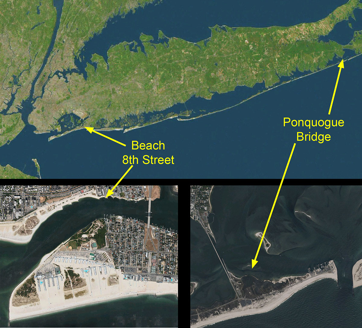
Some of the New Jersey sites (like the railroad bridge or the Belmar Back Bay) are open to divers 24/7, 365 days a year. For others with heavy boat traffic, diving is not allowed during peak boating hours. On Long Island, the three tidal sites (Beach 8th Street, Oak Beach Marine Park, and the old Ponquogue Bridge) all border active boating channels. While diving is not restricted here, situational awareness is paramount.
Site access can vary. The Jersey shore really welcomes divers; there are no issues with parking permits. Street parking is available and safe, and some sites have parking lots. Local groups have even built equipment tables at some of the Jersey sites specifically for divers, to help people gear up. At Ponquogue Bridge on Long Island, parking permits are required due to the proximity to the main bathing beach for Hampton Bays.
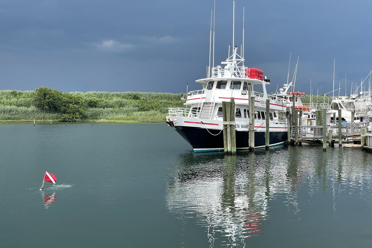
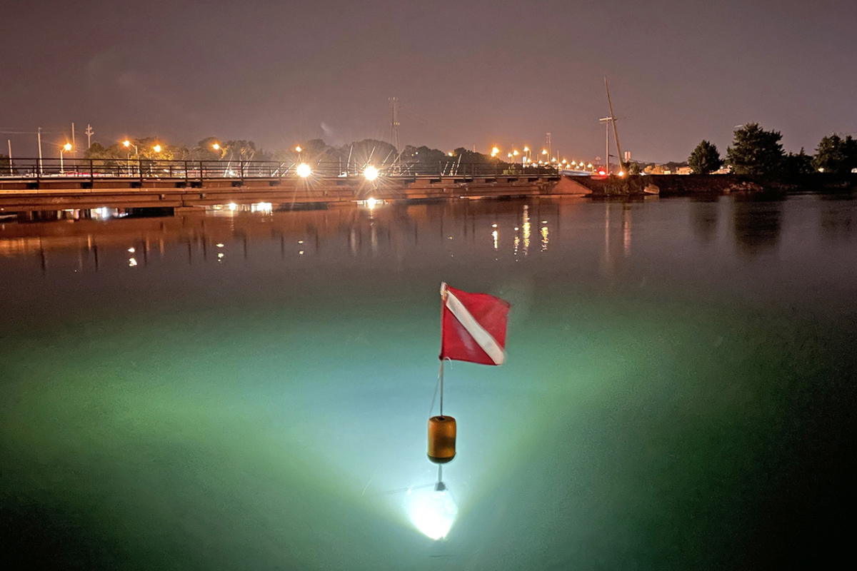
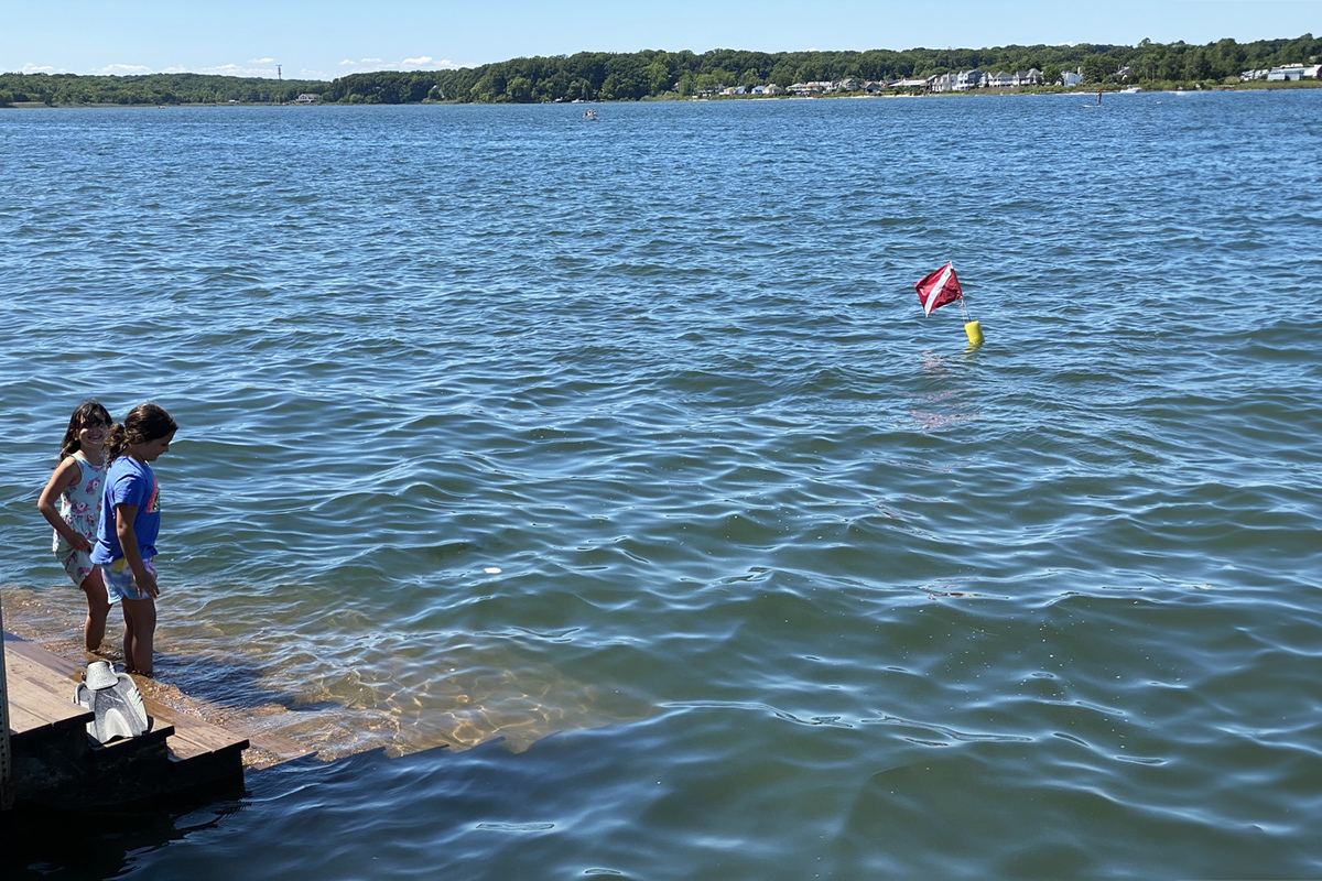
While local ordinances vary from town to town in New Jersey, in general you are required to tow a surface float with a dive flag, to alert boat operators of the presence of a diver in the water. They in turn are restricted from operating near such a flag. On the other hand, in New York state, not only does every municipality that borders the ocean have ordinances AGAINST Scuba Diving, the sport is also outlawed in the entire state park system. However, each regional park system can make their own exceptions to the rules. The Long Island Region does have a “Regional Scuba Permit” for diving in 4 of the State Parks on Long Island.
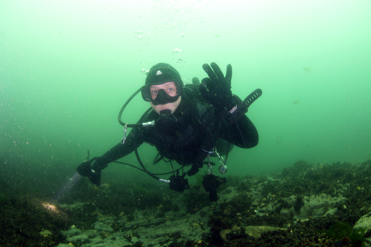
While the shore dive sites sometimes have excellent visibility, this is the exception rather than the rule. That doesn’t mean you can’t have a great dive on most days. Even on days where visibility is particularly bad, I have had a lot of fun doing “muck diving” to photograph the smaller residents of the area. If you like, there are some online groups where people routinely post visibility reports so that you can make a decision before driving to the site.
Macro photographers and other divers prepared to explore the nooks and crannies of these healthy, vibrant marine environments will not be disappointed. In late summer and early fall, not only are the sites dripping with life, but many tropical species which come north on the Gulf Stream can be found. Visibility is often much better in the cold weather of winter and early spring, but there is less obvious sea life to be seen at those times.
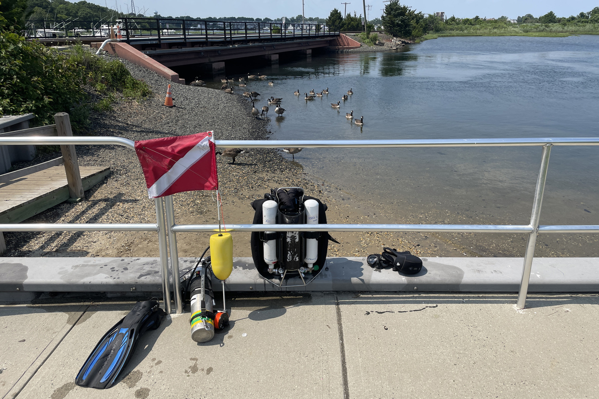
Like for all NYC area dives, two cutting devices should be carried, as you may encounter discarded fishing line and other entanglement hazards. I recommend a trauma shears carried on a harness or other BC attachment. These are cheap and incredibly strong – they can cut heavy rope or wires. Unlike a dive knife, they can be used with minimal risk of injury, even in a panic situation. As a backup, I carry a Trilobite line cutter on the wrist strap of my dive computer. Remember, you may well be sharing a dive site with people who are fishing, and those lines and hooks can end up in your path. It’s not common, but it is possible to get snagged – it happened to me.
Nitrox is unnecessary for these dives, depths are typically less than 20 feet. While a redundant gas supply is often used on boat dives in our area, this is generally not needed for shore diving given the proximity of the surface. A light is a good idea, as there are plenty of small holes to explore. And if you are diving in an area where getting swept away on the current is a potential risk, carry signaling devices (such as a whistle and/or a rescue GPS). And a mesh bag can be useful to help you carry any trash or artifacts you might pick up.
Finally, a compass is very important - it's easy to get lost or disoriented when you aren't on something like a big wreck. While you can navigate by sensing the current, watching the falloff of the bottom depth or following undersea structures (like the inlet seawall), a compass will help you find your way home and avoid ending up in an active shipping channel.
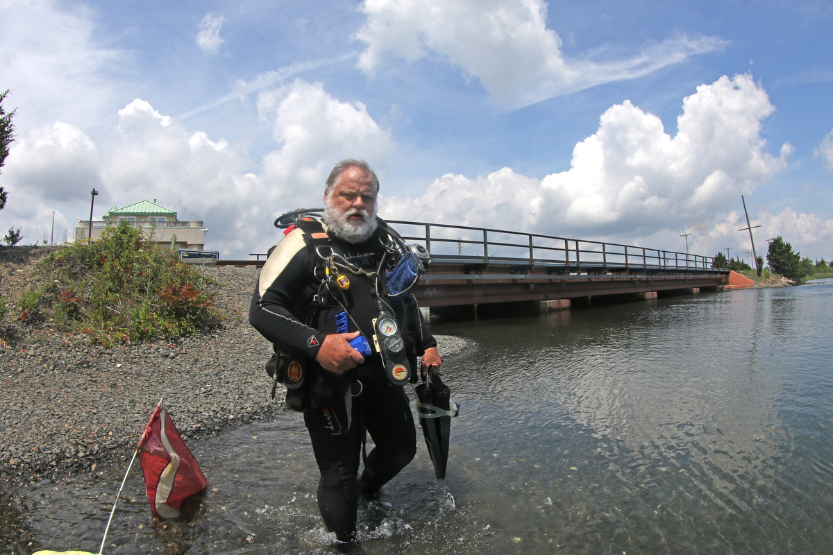
I lock my wallet and phone in my car using the waterproof "valet key" which is detachable from many modern electronic key fobs. I just put the key in my bathing suit pocket, under my wetsuit, where it can't get lost. For people who have electronic keys and no valet key option, the options are to bring a reliable waterproof case (be sure it's secure!), or hide your key somewhere on or near your car.
A supply of fresh water is useful to shore divers, to rinse off sand before loading your car, as is a small tarp or beach mat to stand on while suiting up and gearing down.
Now let’s go over some specific dive sites! Below are the ones that we have the most experience at, but there are a lot more than these if you want to explore. Club member Danny Rivera has an excellent book on diving on Long island, as does former club president David Rosenthal. For New Jersey sites, check out the book by Daniel and Denise Berg, or the one by Tom Gormley and Ben Gualano.
Our charter boat dive trips are amazing, with many historic shipwrecks to explore. And while these dives are deeper with typically better visibility, larger sea life and often fascinating back stories, shore diving has a number of advantages over boat diving.
First of all, once you have your gear, shore diving is very cheap – the cost of an air fill – while charter spots are usually $100-$200. Also, you are not dependent on anyone else’s schedule, only the tides determine when you can dive. The boats stop going out in the off season (December – April), but the ocean is always there. There are no issues with sea sickness, and no cancelled dives due to big waves.
The shallow water is usually warmer as well. While I always wear my dry suit for boat dives, I dive my 5mm wetsuit year-round off the shore. A boat dive typically takes up at least half of a day, requiring you to be at the dock before 6 AM, and not returning until the afternoon. Shore diving can be done in an hour, with plenty of time to enjoy other topside activities with your non-diving friends and family.
Night diving is an incredible experience - animals that hide during the day are out and about after sunset. Bioluminescence is also amazing, and I have seen this in New Jersey. The charter boats very rarely do night dives, but when high slack tide lines up with a reasonable time of the evening, try a night shore dive. Dawn and dusk diving is also an option when the tides are right, it's a lot of fun to watch the undersea world wake up.
One issue with shore diving is that most of them are tidal in nature. While there are a few dive sites directly off the coast in the open ocean, most of these have been covered with sand in recent years, and there is little sea life on the open sandy bottom. Therefore, our shore sites are typically ocean inlets, where the clear sea water floods upstream twice a day, giving the best dive window with minimal current, greater depth and better visibility at “high slack." We are not concerned with low slack, as the water is generally dirtier, with poorer visibility due to the bays and estuaries draining into the site.
Any shore diver should have an app that shows the local tides. Depending on the location of the site and the width of the inlet, getting in the water at the wrong time can be anything from barely noticeable to a significant risk of catastrophe. I will go over specific dive sites later on in this article, but for the most part, it is best to plan your dive around slack tide, both for safety and for visibility.
Tidal water motion follows a cycle, which repeats twice each day. High tide is when the incoming sea water results in the greatest depth, and low tide is shallowest. Slack tide just means that the water stops moving in or out, and there is no tidal flow at all. Generally, high and low tides correspond with slack tide – the ocean floods inwards upstream, raises the water level, and then flows back out to sea with the water level dropping until low tide is reached.
However, there are some situations related to local geography where high tide and slack tide are at slightly different times. In some cases, the tidal station (where the tides are observed for the purpose of creating the tables) is different than the dive site. The more you dive a particular location, the more familiar you will become with these subtle, yet very important, nuances.
Tidal water flow is inversely proportional to the width and depth of the channel. Since the same amount of water has to move through all parts of the inlet during any given time period, it moves faster through narrow passages. An example of this at the Jersey shore would be the Manasquan River railroad bridge, where the streambed is narrow between the abutments. This means that a diver who stays long past slack tide will be squirted eastward at high speed past the piers as the current builds. On the other hand, the Belmar Back Bay is very wide, so the current is rarely an issue, no matter when you enter the water. For some dive sites (like the Shark River jetty), miscalculating your dive timing can mean being swept out to sea.
Typically, you want to plan your dive so that you enter the water as the tide is still flowing upstream, maybe 20-30 minutes before high slack. That means that you will have about an hour, centered on the still water of slack tide, with a small amount of current before and after that. If you need to swim against the current, you will have an easier time of it.
Some of the New Jersey sites (like the railroad bridge or the Belmar Back Bay) are open to divers 24/7, 365 days a year. For others with heavy boat traffic, diving is not allowed during peak boating hours. On Long Island, the three tidal sites (Beach 8th Street, Oak Beach Marine Park, and the old Ponquogue Bridge) all border active boating channels. While diving is not restricted here, situational awareness is paramount.
Site access can vary. The Jersey shore really welcomes divers; there are no issues with parking permits. Street parking is available and safe, and some sites have parking lots. Local groups have even built equipment tables at some of the Jersey sites specifically for divers, to help people gear up. At Ponquogue Bridge on Long Island, parking permits are required due to the proximity to the main bathing beach for Hampton Bays.
While local ordinances vary from town to town in New Jersey, in general you are required to tow a surface float with a dive flag, to alert boat operators of the presence of a diver in the water. They in turn are restricted from operating near such a flag. On the other hand, in New York state, not only does every municipality that borders the ocean have ordinances AGAINST Scuba Diving, the sport is also outlawed in the entire state park system. However, each regional park system can make their own exceptions to the rules. The Long Island Region does have a “Regional Scuba Permit” for diving in 4 of the State Parks on Long Island.
While the shore dive sites sometimes have excellent visibility, this is the exception rather than the rule. That doesn’t mean you can’t have a great dive on most days. Even on days where visibility is particularly bad, I have had a lot of fun doing “muck diving” to photograph the smaller residents of the area. If you like, there are some online groups where people routinely post visibility reports so that you can make a decision before driving to the site.
Macro photographers and other divers prepared to explore the nooks and crannies of these healthy, vibrant marine environments will not be disappointed. In late summer and early fall, not only are the sites dripping with life, but many tropical species which come north on the Gulf Stream can be found. Visibility is often much better in the cold weather of winter and early spring, but there is less obvious sea life to be seen at those times.
Like for all NYC area dives, two cutting devices should be carried, as you may encounter discarded fishing line and other entanglement hazards. I recommend a trauma shears carried on a harness or other BC attachment. These are cheap and incredibly strong – they can cut heavy rope or wires. Unlike a dive knife, they can be used with minimal risk of injury, even in a panic situation. As a backup, I carry a Trilobite line cutter on the wrist strap of my dive computer. Remember, you may well be sharing a dive site with people who are fishing, and those lines and hooks can end up in your path. It’s not common, but it is possible to get snagged – it happened to me.
Nitrox is unnecessary for these dives, depths are typically less than 20 feet. While a redundant gas supply is often used on boat dives in our area, this is generally not needed for shore diving given the proximity of the surface. A light is a good idea, as there are plenty of small holes to explore. And if you are diving in an area where getting swept away on the current is a potential risk, carry signaling devices (such as a whistle and/or a rescue GPS). And a mesh bag can be useful to help you carry any trash or artifacts you might pick up.
Finally, a compass is very important - it's easy to get lost or disoriented when you aren't on something like a big wreck. While you can navigate by sensing the current, watching the falloff of the bottom depth or following undersea structures (like the inlet seawall), a compass will help you find your way home and avoid ending up in an active shipping channel.
I lock my wallet and phone in my car using the waterproof "valet key" which is detachable from many modern electronic key fobs. I just put the key in my bathing suit pocket, under my wetsuit, where it can't get lost. For people who have electronic keys and no valet key option, the options are to bring a reliable waterproof case (be sure it's secure!), or hide your key somewhere on or near your car.
A supply of fresh water is useful to shore divers, to rinse off sand before loading your car, as is a small tarp or beach mat to stand on while suiting up and gearing down.
Now let’s go over some specific dive sites! Below are the ones that we have the most experience at, but there are a lot more than these if you want to explore. Club member Danny Rivera has an excellent book on diving on Long island, as does former club president David Rosenthal. For New Jersey sites, check out the book by Daniel and Denise Berg, or the one by Tom Gormley and Ben Gualano.
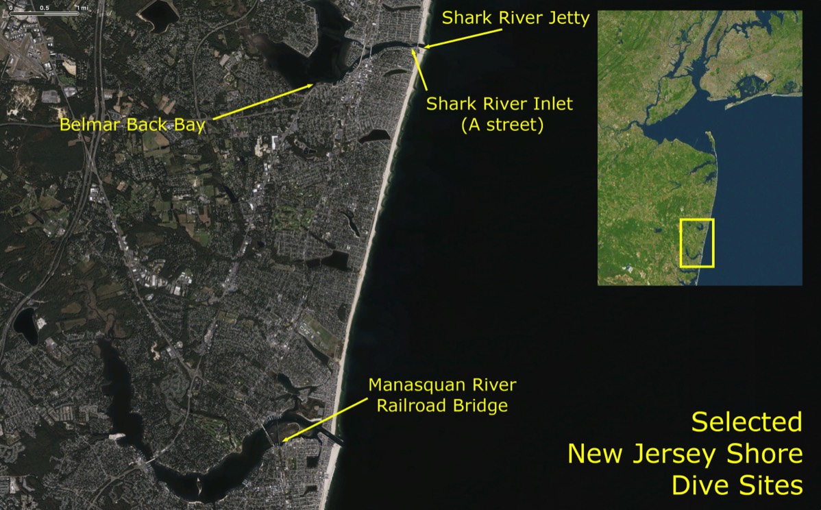
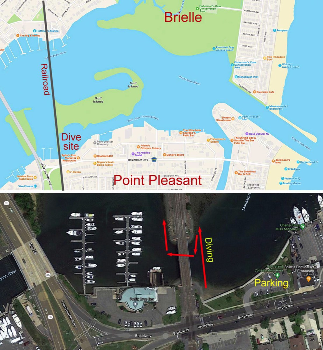
MANASQUAN RIVER RAILROAD BRIDGE
The railroad bridge is my favorite dive in this area –plentiful sea life, an easy entry, convenient parking, the lack of time restrictions or boat traffic, and the fact that there is not much risk of getting swept downriver or out to sea.
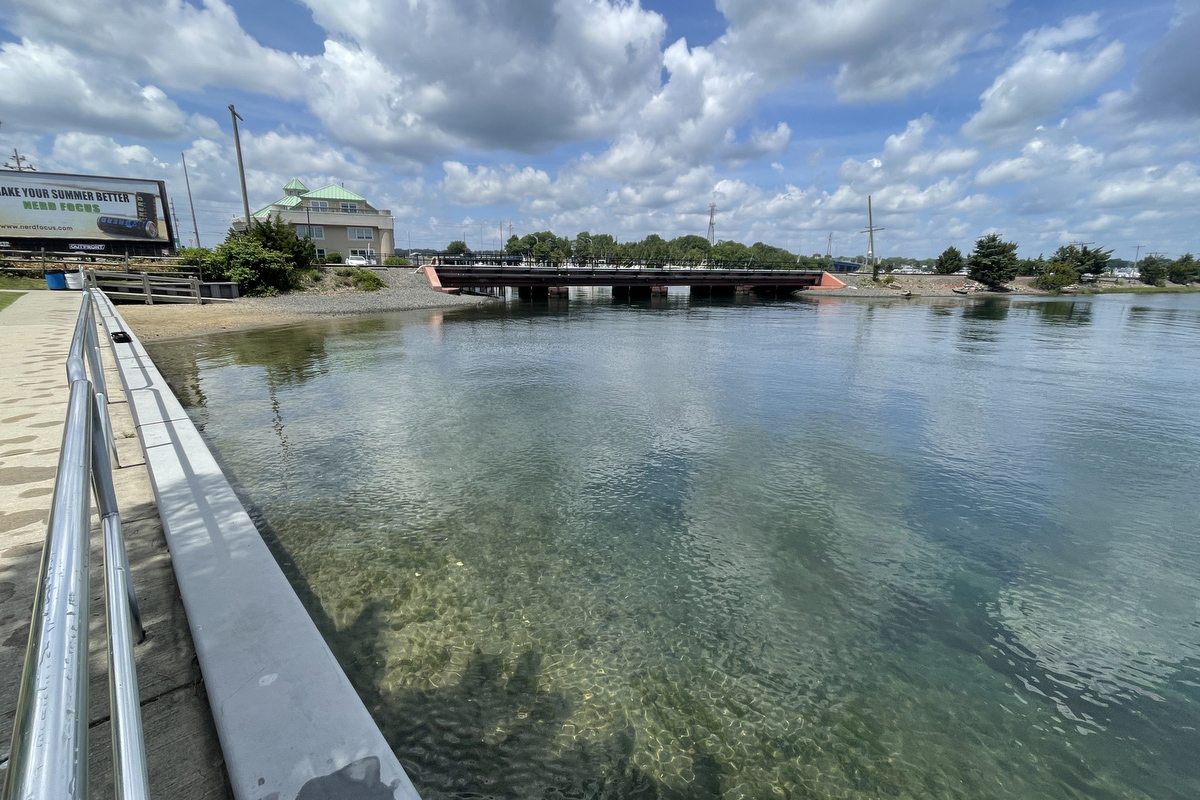
The site is in the Gull Island County Park, on the south shore of the Manasquan river, in the town of Point Pleasant. The land seen looking north across the water is Gull Island, a conservation area. Past that is the rest of the river and the north shore in Brielle, but diving is confined to the area near the bridge and to the immediate east of it, downriver.
There is a parking lot reserved for anyone using the Gull Island county park, right next to Spike’s restaurant (a great place for a post-dive meal). You can also street park on Broadway, which is even closer to the entry point. There is no public bathroom at the site, but there usually is a porta-potty. The site is open to diving year-round, 24/7.
There is a gear table next to the parking lot, or you can gear up right at the seawall – it’s at a good height for donning your rig. Entry is an easy stroll down a ramp to a little beach on the east side of the south end of the bridge. Get in the water, then watch the current and slip down the bank to the site once it has reasonably slowed – slack tide is often 30-40 minutes after the published high tide. You can estimate the flow by watching the water ripple around the bridge.
While knowing the tides is important for all inlet diving, getting caught in an outgoing tide here is not as much of a problem as it might be elsewhere. The water widens east of the bridge, which means that the flow drops off. Also, you are fairly far from the ocean. If necessary, you can just swim south and make it back to the entry point by “walking” along the wall.
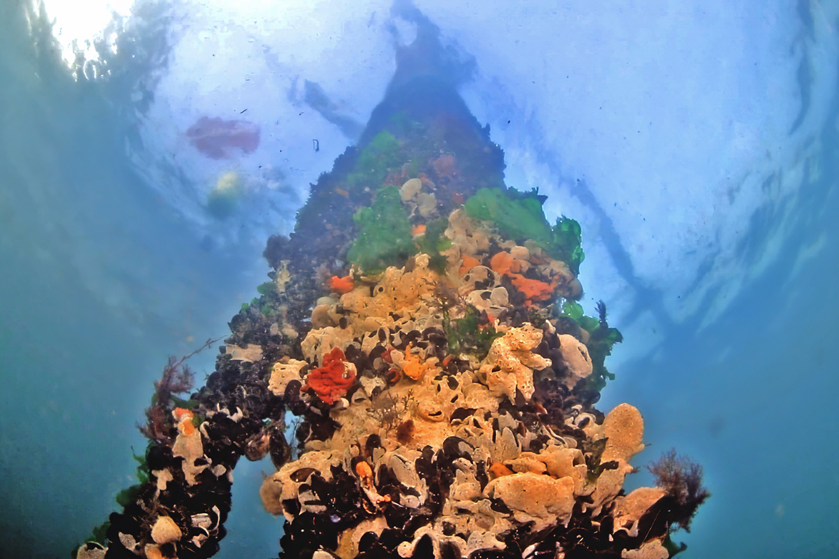
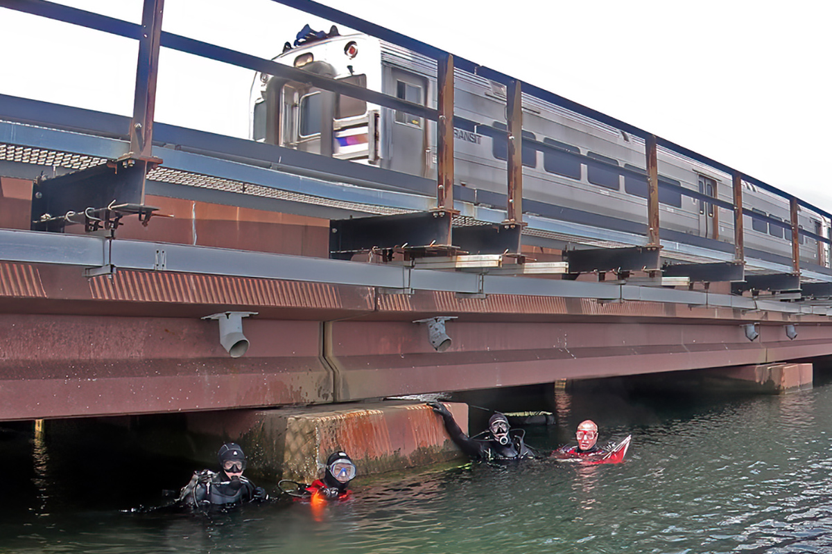
Most of the sea life is right under the bridge. But people also dive in the wider area to the east of the site, where there are larger fish, attracting spearhunters on scuba or freediving. If you go through the bridge piles and keep swimming west, you will be heading towards the marina - don’t do this. Stay away from the docks, and stick to the area close to the bridge. There is virtually no boat traffic near it, apart from the occasional kayak.
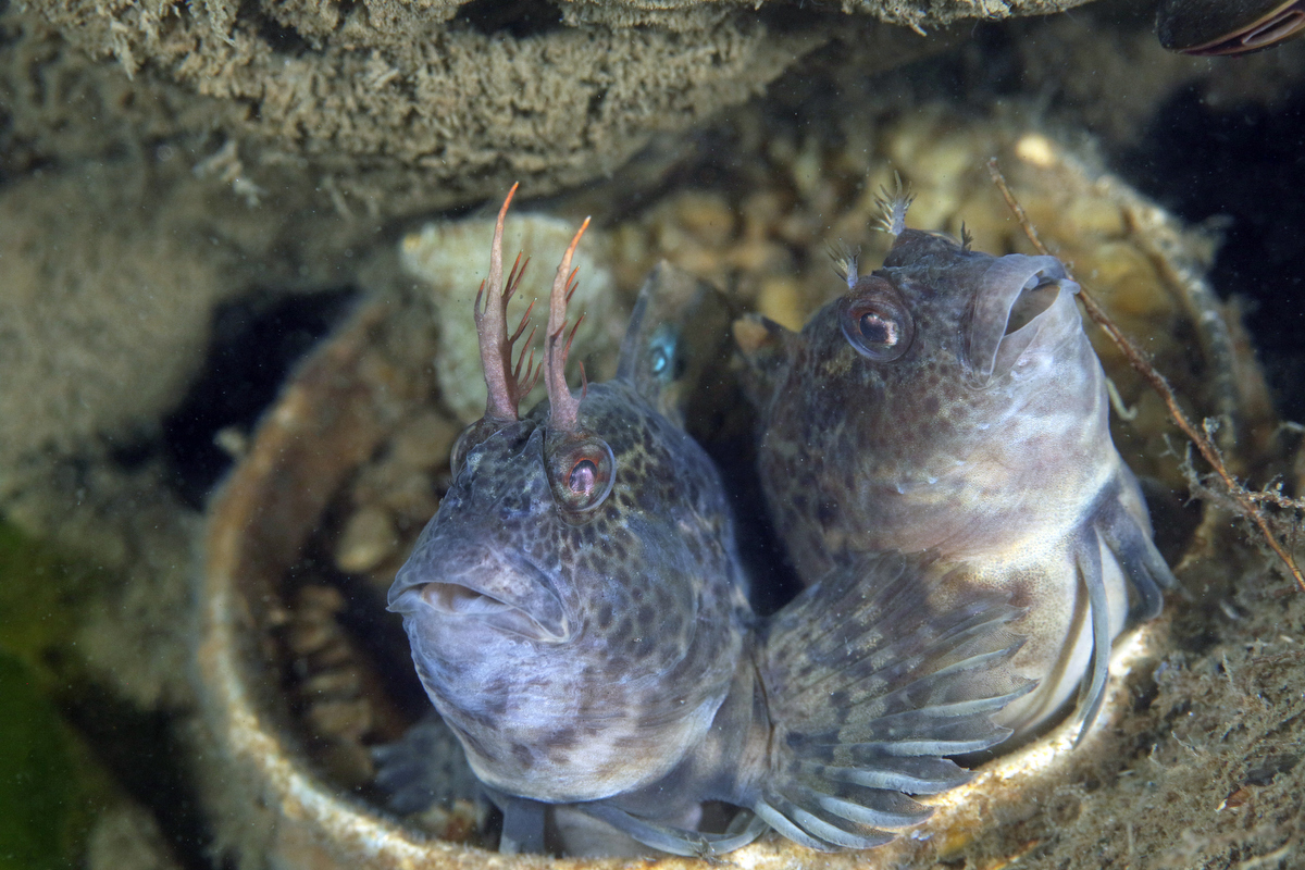
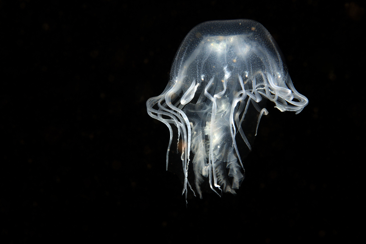
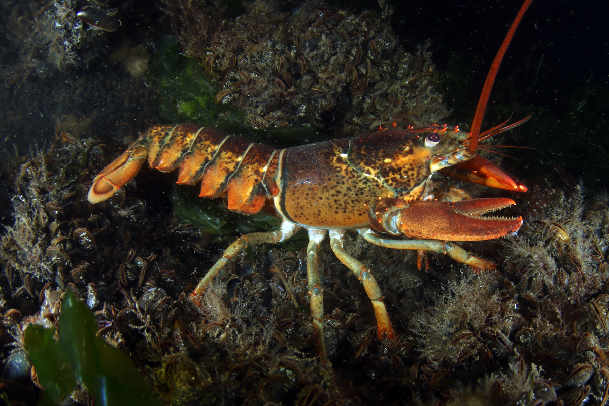
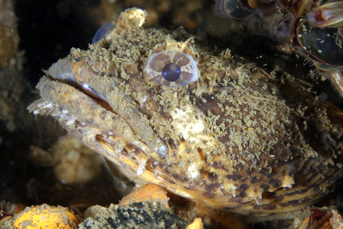
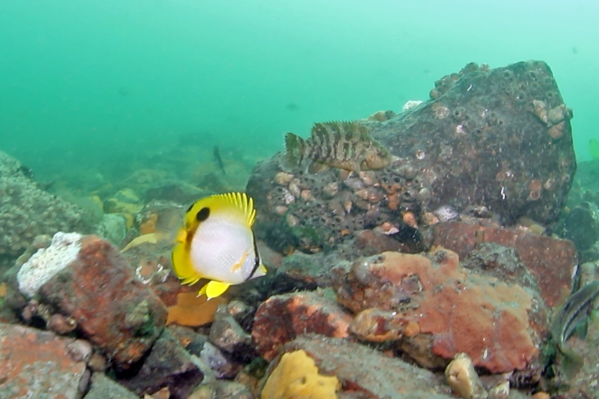
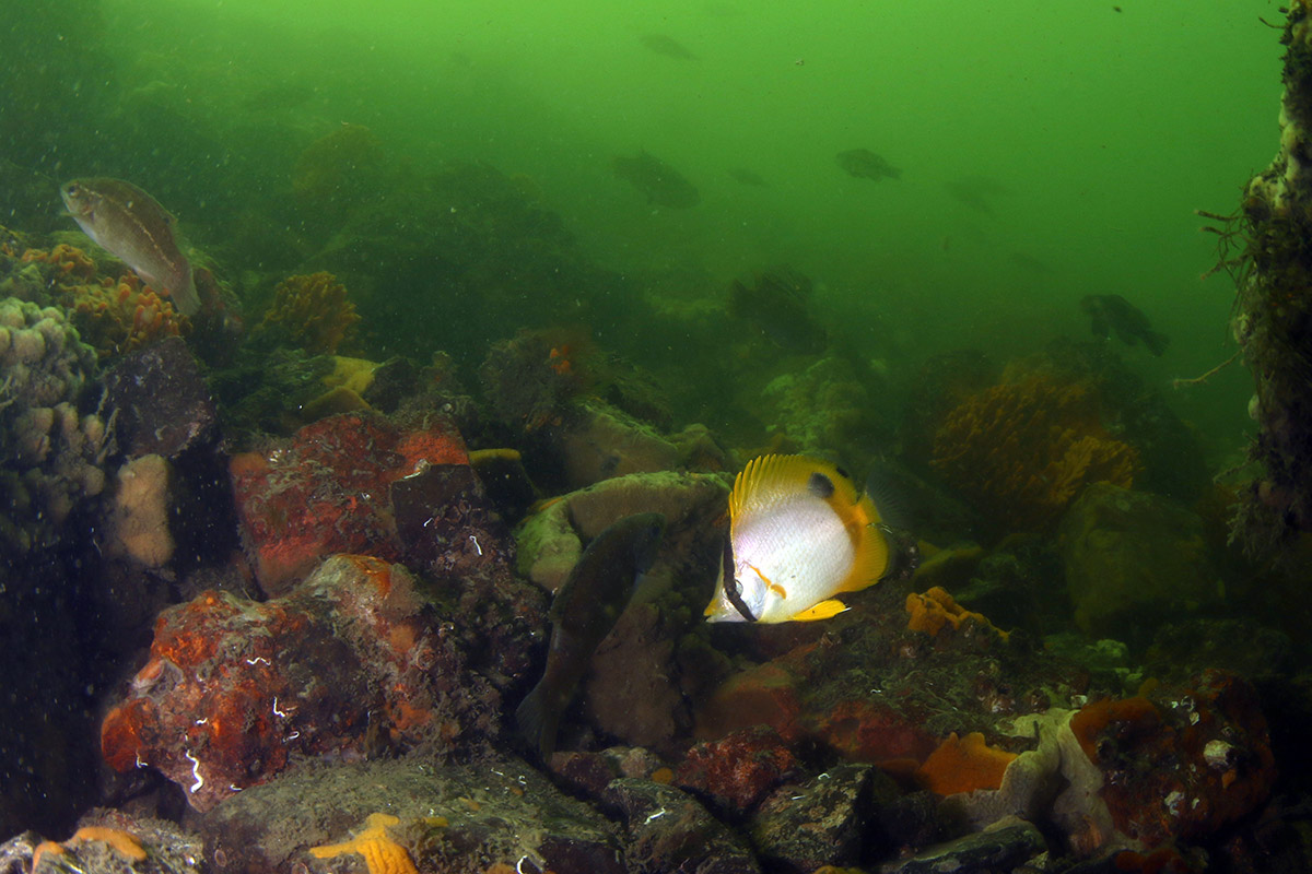
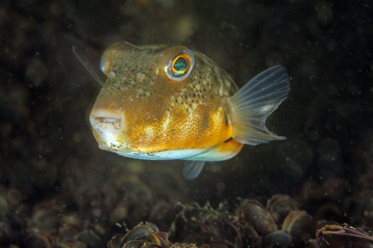
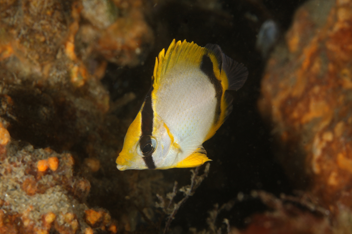
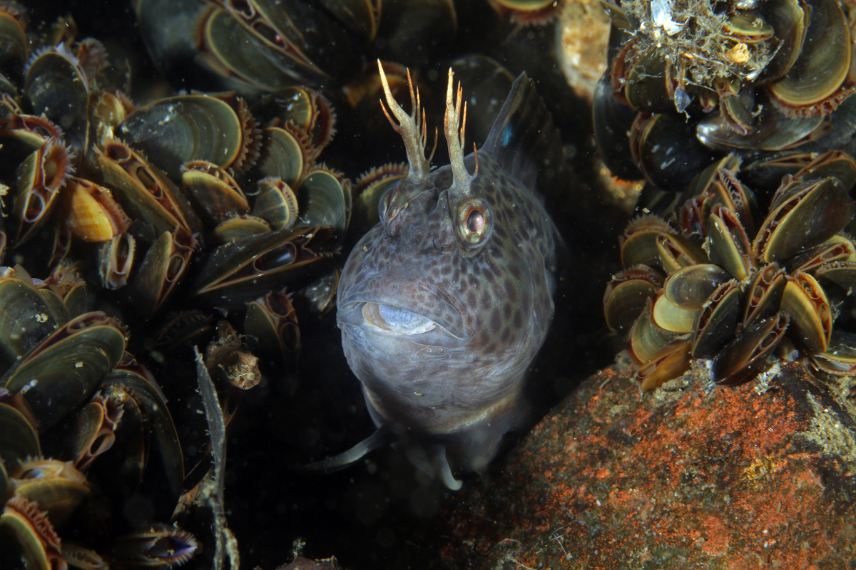
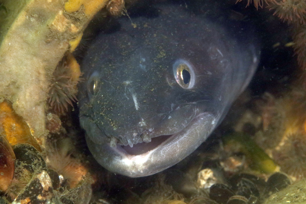
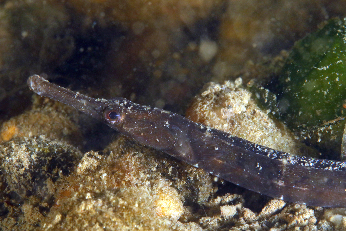
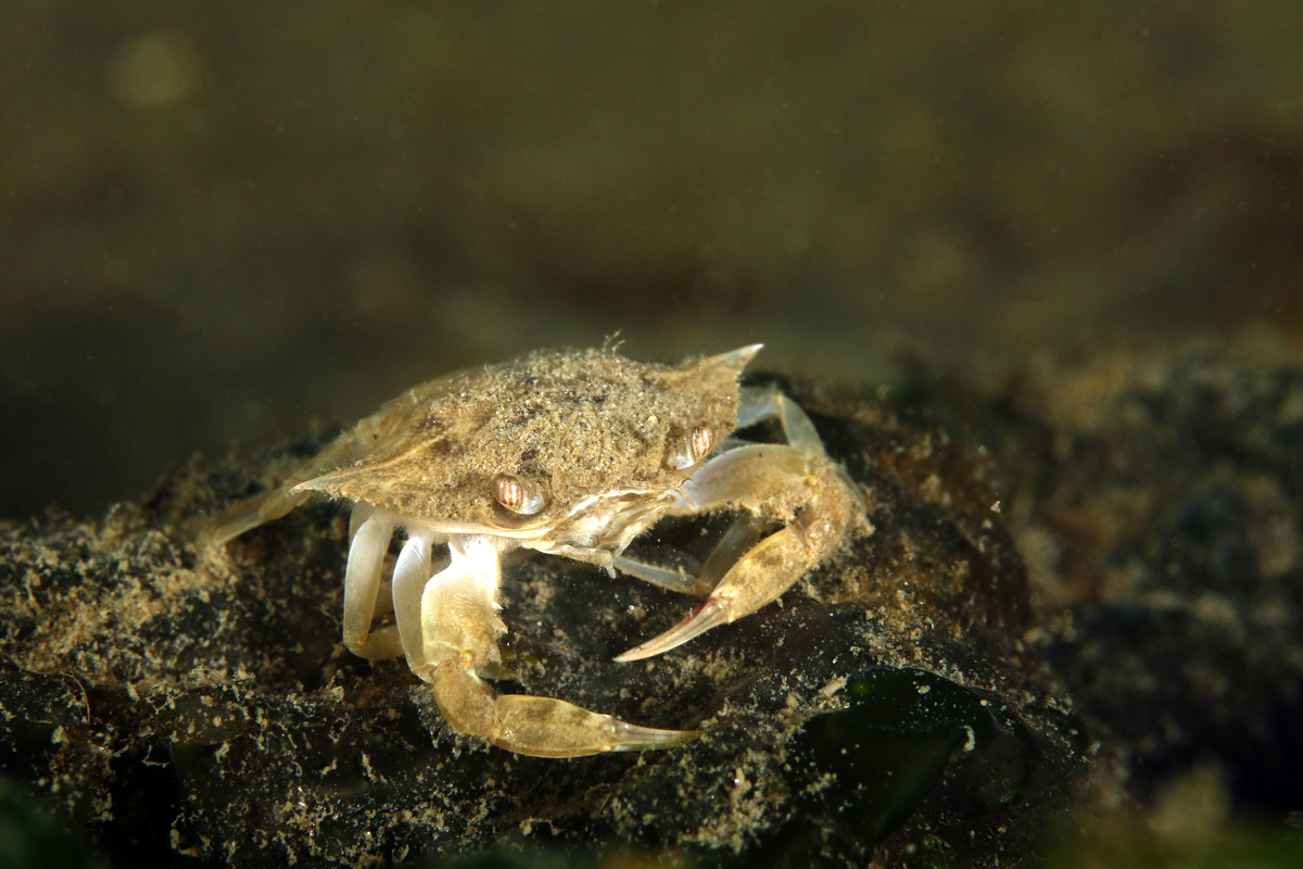
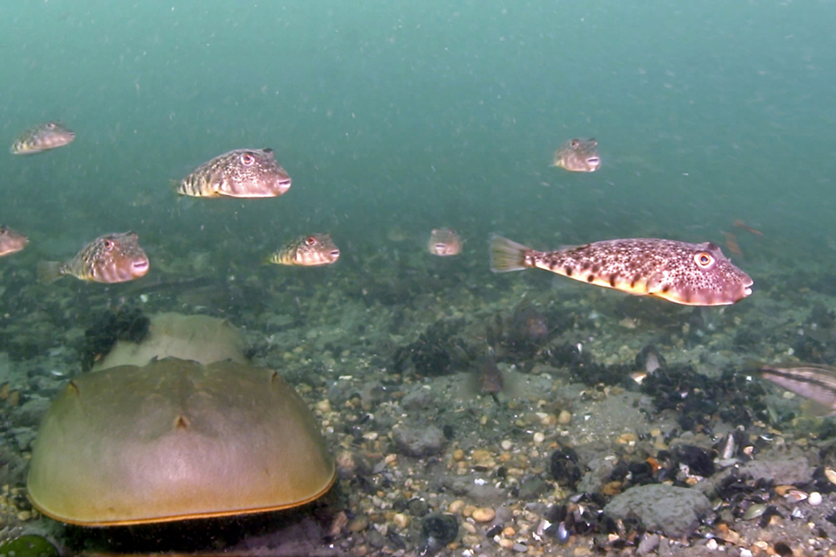
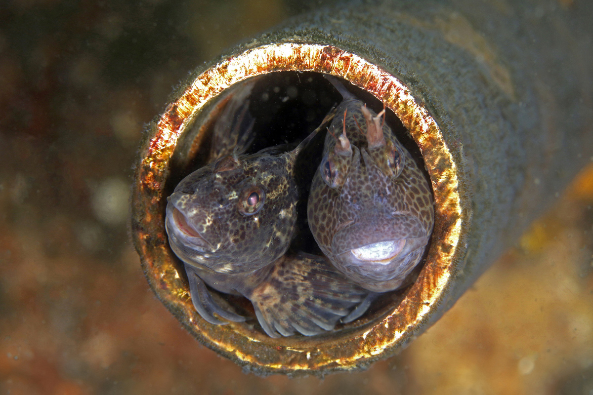
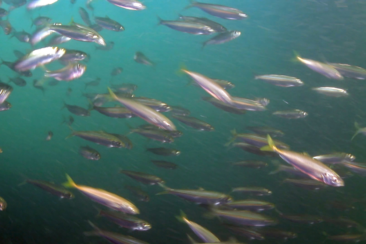
There is a lot of biodiversity here, with blennies making territorial homes in cans, pipes and other secure spots – these are commonly seen on the river bank to the north of the bridge on the western (marina) side. Toadfish are found in the dense mussel beds under the bridge. Schools of northern puffers coast over the shoals, and you can see horseshoe crabs, skates, eel, lobsters, flounder and juvenile cunner. In late season, butterflyfish are often in the slope just off the entry point.
As mentioned above, the current at this site really picks up as you stay longer and longer past slack tide. I find this to be a great time to dive. While it’s harder to anchor yourself for photography, letting the current carry you under the bridge, superman style, is a lot of fun. If you don’t mind crawling back upcurrent, you can swim south to the shallows, head back west to the bridge, pull yourself through, and take the ride again. And occasionally you will be in the water as a train goes over the bridge – another exciting part of the dive, as you hear and feel the thundering above.
The railroad bridge is my favorite dive in this area –plentiful sea life, an easy entry, convenient parking, the lack of time restrictions or boat traffic, and the fact that there is not much risk of getting swept downriver or out to sea.
The site is in the Gull Island County Park, on the south shore of the Manasquan river, in the town of Point Pleasant. The land seen looking north across the water is Gull Island, a conservation area. Past that is the rest of the river and the north shore in Brielle, but diving is confined to the area near the bridge and to the immediate east of it, downriver.
There is a parking lot reserved for anyone using the Gull Island county park, right next to Spike’s restaurant (a great place for a post-dive meal). You can also street park on Broadway, which is even closer to the entry point. There is no public bathroom at the site, but there usually is a porta-potty. The site is open to diving year-round, 24/7.
There is a gear table next to the parking lot, or you can gear up right at the seawall – it’s at a good height for donning your rig. Entry is an easy stroll down a ramp to a little beach on the east side of the south end of the bridge. Get in the water, then watch the current and slip down the bank to the site once it has reasonably slowed – slack tide is often 30-40 minutes after the published high tide. You can estimate the flow by watching the water ripple around the bridge.
While knowing the tides is important for all inlet diving, getting caught in an outgoing tide here is not as much of a problem as it might be elsewhere. The water widens east of the bridge, which means that the flow drops off. Also, you are fairly far from the ocean. If necessary, you can just swim south and make it back to the entry point by “walking” along the wall.
Most of the sea life is right under the bridge. But people also dive in the wider area to the east of the site, where there are larger fish, attracting spearhunters on scuba or freediving. If you go through the bridge piles and keep swimming west, you will be heading towards the marina - don’t do this. Stay away from the docks, and stick to the area close to the bridge. There is virtually no boat traffic near it, apart from the occasional kayak.
There is a lot of biodiversity here, with blennies making territorial homes in cans, pipes and other secure spots – these are commonly seen on the river bank to the north of the bridge on the western (marina) side. Toadfish are found in the dense mussel beds under the bridge. Schools of northern puffers coast over the shoals, and you can see horseshoe crabs, skates, eel, lobsters, flounder and juvenile cunner. In late season, butterflyfish are often in the slope just off the entry point.
As mentioned above, the current at this site really picks up as you stay longer and longer past slack tide. I find this to be a great time to dive. While it’s harder to anchor yourself for photography, letting the current carry you under the bridge, superman style, is a lot of fun. If you don’t mind crawling back upcurrent, you can swim south to the shallows, head back west to the bridge, pull yourself through, and take the ride again. And occasionally you will be in the water as a train goes over the bridge – another exciting part of the dive, as you hear and feel the thundering above.
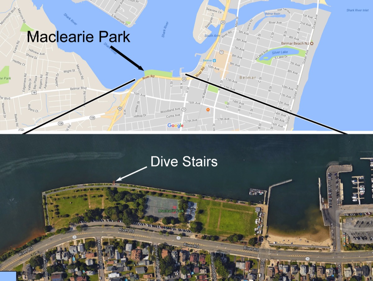
BELMAR BACK BAY
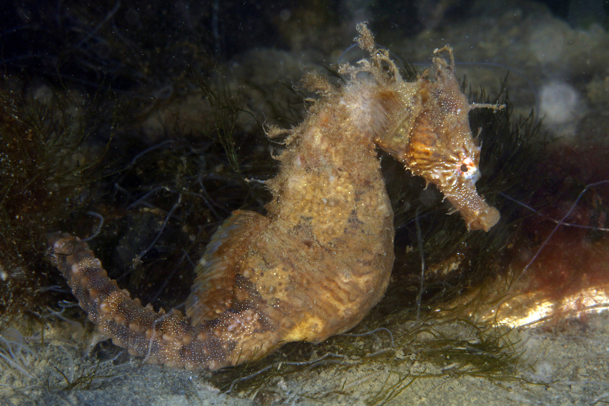
This very wide portion of a tidal estuary between Belmar and Avon-by-the-Sea. The dive site is mainly the shallow water near the southern seawall, where seahorses and other small critters may be found in 6 feet of water. However, swimming north towards the center of the channel will get you more depth (around 15 feet) and bigger fish. There are no mussel beds or other riverbed structure like you find on the bridge, which means a lot less sea life. Nevertheless, if you look in the fringes of the sea grass on the sandy bottom or along the wall, you may find some interesting fish and crabs.
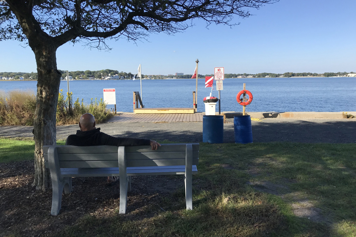
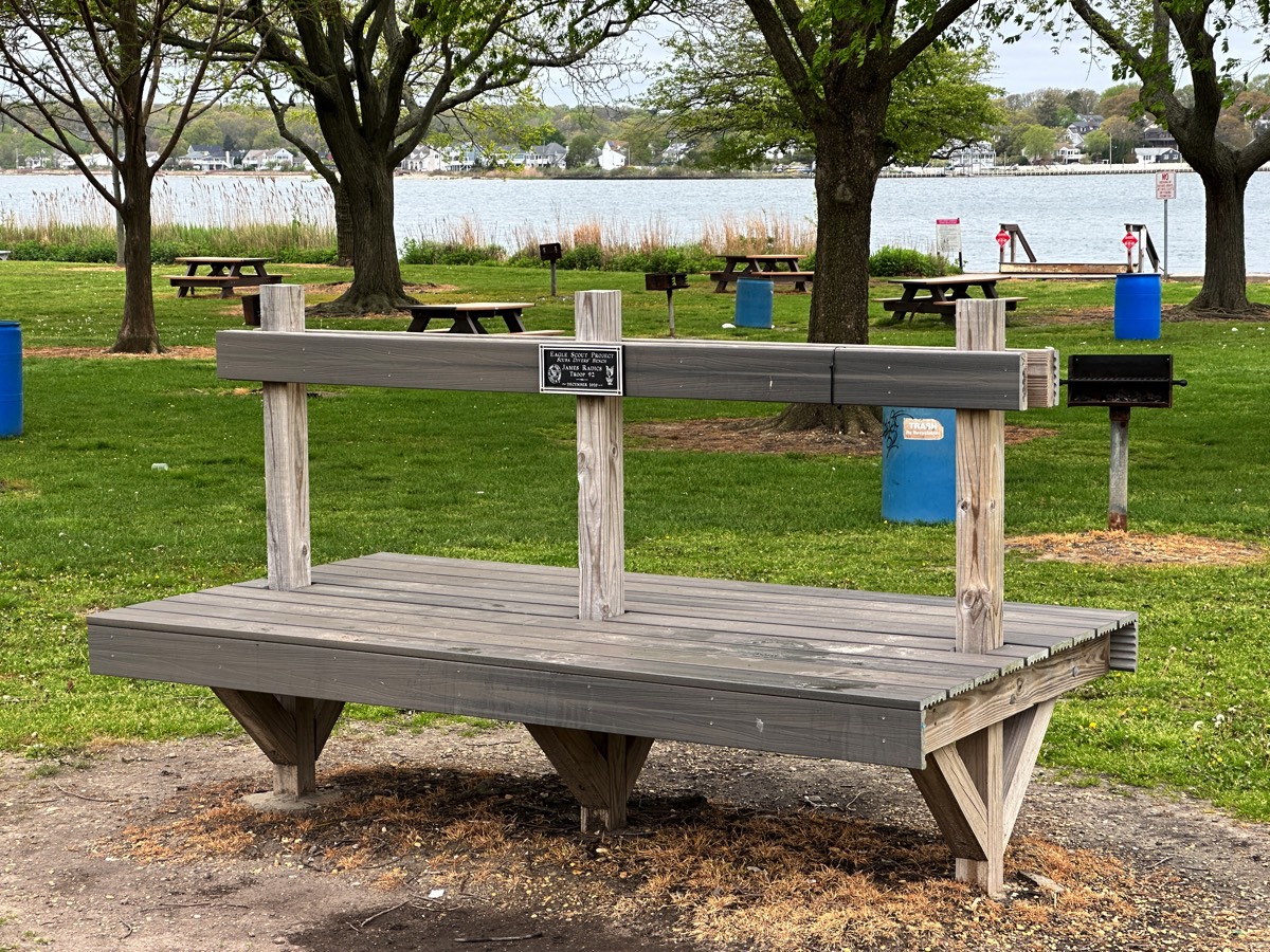
The entrance to the dive site is down a set of wooden stairs (installed by the town for divers) in a public facility called Maclearie Park. There is a gearing bench for divers, similar to the one at the Railroad bridge. Maclearie can get pretty crowded on a nice summer weekend, since the town also provides picnic tables and grills. There are bathrooms, tennis courts and a playground.
Because the Back Bay is so wide, the current is usually negligible. Nevertheless, getting in around high tide is recommended, just because most of the site is so shallow. Also, the water tends to be clearer at high tide, due to the influx of relatively clean ocean water. The site is open to diving year-round, 24/7.
This very wide portion of a tidal estuary between Belmar and Avon-by-the-Sea. The dive site is mainly the shallow water near the southern seawall, where seahorses and other small critters may be found in 6 feet of water. However, swimming north towards the center of the channel will get you more depth (around 15 feet) and bigger fish. There are no mussel beds or other riverbed structure like you find on the bridge, which means a lot less sea life. Nevertheless, if you look in the fringes of the sea grass on the sandy bottom or along the wall, you may find some interesting fish and crabs.
The entrance to the dive site is down a set of wooden stairs (installed by the town for divers) in a public facility called Maclearie Park. There is a gearing bench for divers, similar to the one at the Railroad bridge. Maclearie can get pretty crowded on a nice summer weekend, since the town also provides picnic tables and grills. There are bathrooms, tennis courts and a playground.
Because the Back Bay is so wide, the current is usually negligible. Nevertheless, getting in around high tide is recommended, just because most of the site is so shallow. Also, the water tends to be clearer at high tide, due to the influx of relatively clean ocean water. The site is open to diving year-round, 24/7.
A STREET IN BELMAR
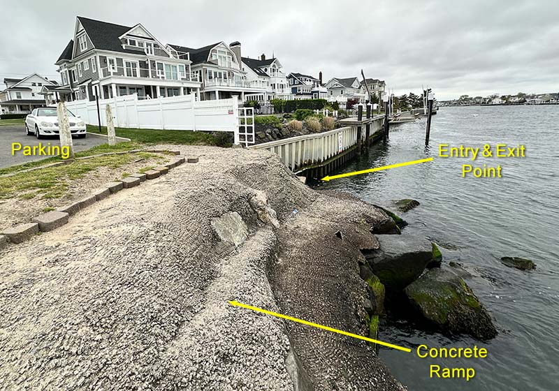
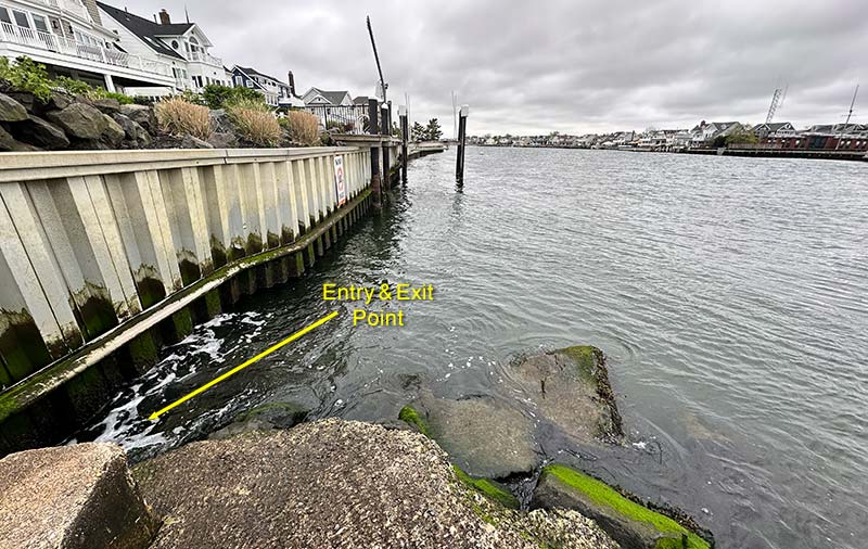
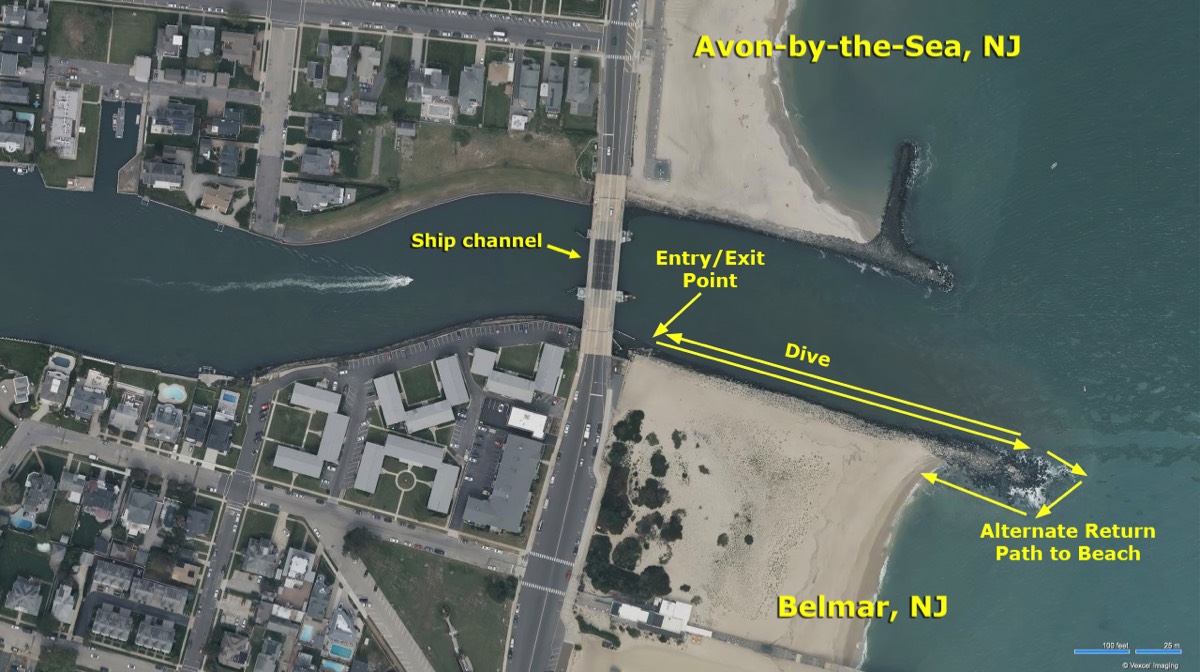
Heading east from the Back Bay, the next dive site is a stretch on the south shore of the Shark River inlet, with an entrance/exit point where A street turns at the water. Parking is more limited here, and on a popular dive or fishing day, you may need to park a block or two away. The entry is more difficult here than at the bridge or the Back Bay, although the town has created a concrete ramp leading from the road down to the large boulders that line this waterway. Once at the end of the ramp, you climb down onto the rocks and enter the water. This can be challenging if you are carrying heavy gear like a camera. Carry your fins in your hand and put them on in the water or when sitting at the edge - it’s not a good idea to try to walk in them.
I usually just drop to the bottom here at around 15 feet and swim east, hugging the rocks along the shore, staying out of the main channel. The current can be much more of an issue here, you don’t want to be caught far away from the entry/exit point when the tide turns. Get in the water about 20-30 minutes before high slack tide, and start swimming east into the incoming water. When you feel the current stopping, that’s a good time to turn your dive and head back, again facing into the water flow. By planning your dive around high slack, you won’t have long swims in very heavy current to deal with. Usually, your turning point will be just before the Ocean Avenue bridge.
You typically see bigger fish here than at the Back Bay or the railroad bridge, due to the proximity of the ocean. There is a small protected area just west of A street on the south shore of the river, behind the pilings near the apartment complex seawall. I find that you can sometimes extend your dive a bit after you have returned to the entry/exit point if you still have gas, as it is shielded from the current. Don’t venture too far from the exit point in the face of an outgoing tide.
There can be a good deal of large boat traffic in this area. For this reason, diving is prohibited between 8:00 AM and 5:30 PM, between May 1st and October 1st. But even when diving is allowed, be aware that big boats can show up at any time.

BELMAR JETTY
To get even further out (and to potentially see bigger sea life), you can also dive on the east side of the Ocean Avenue bridge. The entry here is by way of the beach, and you have to scramble down the large boulders near the bridge abutment. This is one of the more difficult entries in the area, and there are also likely to be people fishing on the jetty.
Again, this is a strong tidal dive, and miscalculating can end up with you being swept out into the ocean. Be sure to time your entry so that you can easily swim back to the exit point. Some very confident and strong divers will swim out to the end of the rocks, then go around the tip and swim back to the beach on the opposite side of the jetty.
Just like A street, hours are restricted between May 1st and October 1st (no diving from 8:00 AM to 5:30 PM).
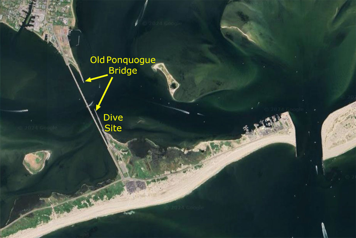
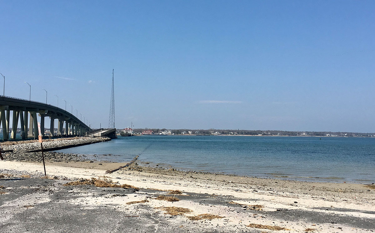
PONQUOGUE BRIDGE
Ponquogue Bridge easily takes the title of best shore dive on Long Island. Located in the town of Hampton Bays the bridge crosses Shinnecock Bay just a few miles west of Shinnecock inlet. The visibility tends to be good, beach access is easy, and the biodiversity is unmatched locally. It is also known for its intense tidal currents. Only dive this one at high slack tide. There are actually two Ponquogue Bridges, a new road bridge, and an old draw bridge which has been cut in half to form two fishing piers. Most diving is done under the Old Bridge. A typical dive involves entering the water from the south side of the bridge and following the east side of the jetty bulkhead. Depth along the bulkhead starts ankle deep and gradually drops to about 8 ft right before the start of the Old Bridge. Make sure you stay on the east side, the west side crosses a boat launch and channel and should be avoided. There is no current in this section of the dive, and it’s a good spot to put on your fins and do a buoyancy check. The next step involves timing. The bridge is very close to Shinnecock inlet and very strong tidal currents pass through. Diving under the bridge should only be attempted within a half hour before and after High Slack tide. Any later or earlier and your dive will involve hugging a bridge piling or a ride out the inlet. Assuming you timed the dive correctly once you get to the end of the bulkhead you should be able to ride the tail end of the incoming tide under the bridge.
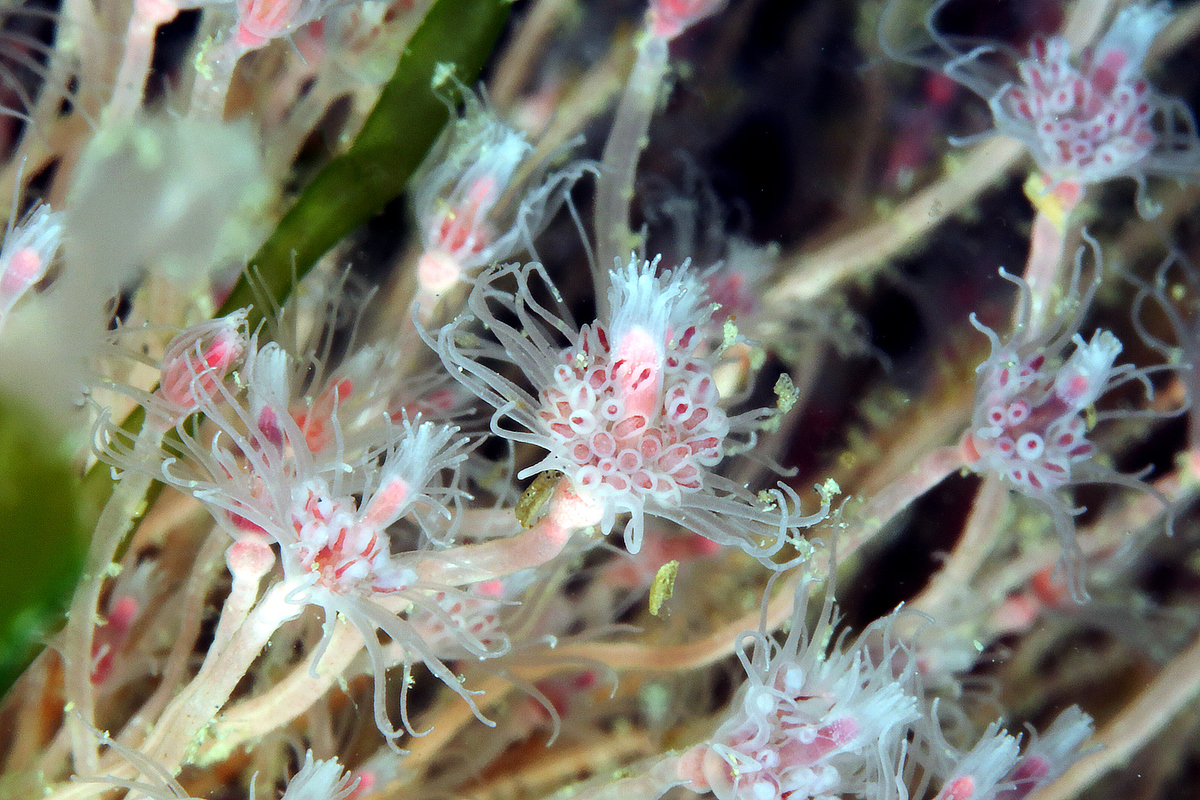
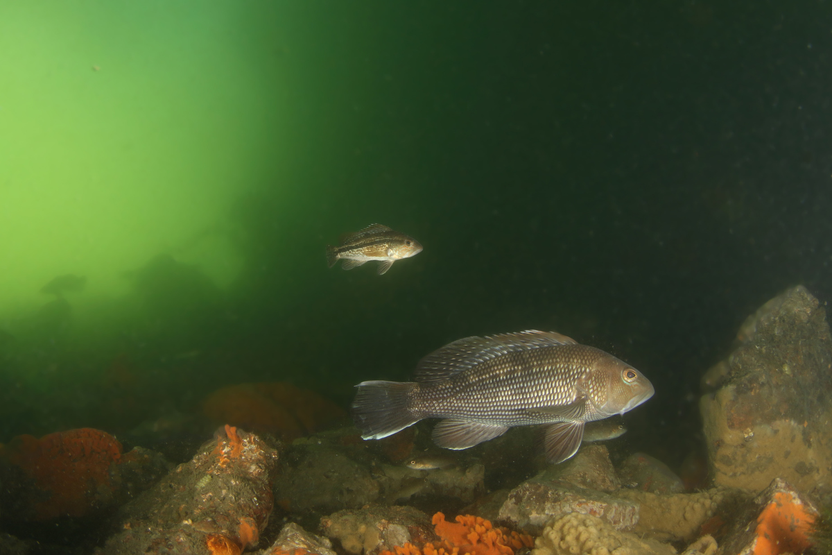
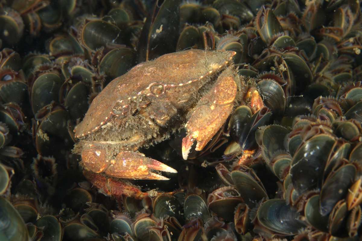
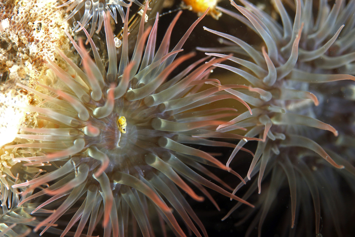
Once under the bridge you will see sets of four wooden pilings stretching north. Each set is spaced about 15 ft apart and there are rock piles protecting the outermost pilings on the east and west sides. The rocks and the pilings provide a bit of structure and protection from the current. It also provides habitat for a huge variety of marine life. There are mussels beds, red beard sponges, northern star coral, and small anemones covering every hard surface. You will see crabs scurrying everywhere. Fish life includes sea bass, cunner, black fish, sea robins, and fluke. If you go slow and have a good eye it is also possible to spot sea horses, pipefish and eels.
Once the tide begins to turn you should start to make your way back south until you get to the end of the old bridge, and that point you can follow the outgoing tide back to the shelter of the bulkhead. Boating is not allowed underneath the Old Ponquogue bridge or near the bulkhead and a dive flag is not required under the bridge, but there are boats in the surrounding area and care should be taken to stay in the dive area.
As long as the dive is timed right Ponquogue is an incredibly rewarding dive. Visibility tends to be better than average, typically 8-10 ft, but visibility of 20ft or more is not unheard of, even in the summer months. Another interesting aspect to diving the bridge is that by July, once the water has warmed up to the high 60’s, the bridge becomes one of the best places in the north east to spot juvenile tropical fish. These tropical strays are swept north by the gulf stream, and settle along the rocks and pilings of the bridge. The number of tropicals and species to be found are highly variable year to year, but they can include butterfly fish, surgeonfish, angelfish, damselfish, groupers, snappers, triggerfish, puffers, and even the occasional lionfish. These tropical fish can be found swimming under the bridge through the summer and fall up until water temperatures drop after which these summer visitors will die off.
The one downside to this site is the parking. Hamptons pricing applies. There is a very convenient parking lot at the south side of the bridge, but unfortunately this lot requires a Ponquogue Bridge Marine Park Parking Permit from the town of Southampton. The Permit is $100 per year. Alternatively there is beach parking across the street for $25 a day,
Ponquogue Bridge easily takes the title of best shore dive on Long Island. Located in the town of Hampton Bays the bridge crosses Shinnecock Bay just a few miles west of Shinnecock inlet. The visibility tends to be good, beach access is easy, and the biodiversity is unmatched locally. It is also known for its intense tidal currents. Only dive this one at high slack tide. There are actually two Ponquogue Bridges, a new road bridge, and an old draw bridge which has been cut in half to form two fishing piers. Most diving is done under the Old Bridge. A typical dive involves entering the water from the south side of the bridge and following the east side of the jetty bulkhead. Depth along the bulkhead starts ankle deep and gradually drops to about 8 ft right before the start of the Old Bridge. Make sure you stay on the east side, the west side crosses a boat launch and channel and should be avoided. There is no current in this section of the dive, and it’s a good spot to put on your fins and do a buoyancy check. The next step involves timing. The bridge is very close to Shinnecock inlet and very strong tidal currents pass through. Diving under the bridge should only be attempted within a half hour before and after High Slack tide. Any later or earlier and your dive will involve hugging a bridge piling or a ride out the inlet. Assuming you timed the dive correctly once you get to the end of the bulkhead you should be able to ride the tail end of the incoming tide under the bridge.
Once under the bridge you will see sets of four wooden pilings stretching north. Each set is spaced about 15 ft apart and there are rock piles protecting the outermost pilings on the east and west sides. The rocks and the pilings provide a bit of structure and protection from the current. It also provides habitat for a huge variety of marine life. There are mussels beds, red beard sponges, northern star coral, and small anemones covering every hard surface. You will see crabs scurrying everywhere. Fish life includes sea bass, cunner, black fish, sea robins, and fluke. If you go slow and have a good eye it is also possible to spot sea horses, pipefish and eels.
Once the tide begins to turn you should start to make your way back south until you get to the end of the old bridge, and that point you can follow the outgoing tide back to the shelter of the bulkhead. Boating is not allowed underneath the Old Ponquogue bridge or near the bulkhead and a dive flag is not required under the bridge, but there are boats in the surrounding area and care should be taken to stay in the dive area.
As long as the dive is timed right Ponquogue is an incredibly rewarding dive. Visibility tends to be better than average, typically 8-10 ft, but visibility of 20ft or more is not unheard of, even in the summer months. Another interesting aspect to diving the bridge is that by July, once the water has warmed up to the high 60’s, the bridge becomes one of the best places in the north east to spot juvenile tropical fish. These tropical strays are swept north by the gulf stream, and settle along the rocks and pilings of the bridge. The number of tropicals and species to be found are highly variable year to year, but they can include butterfly fish, surgeonfish, angelfish, damselfish, groupers, snappers, triggerfish, puffers, and even the occasional lionfish. These tropical fish can be found swimming under the bridge through the summer and fall up until water temperatures drop after which these summer visitors will die off.
The one downside to this site is the parking. Hamptons pricing applies. There is a very convenient parking lot at the south side of the bridge, but unfortunately this lot requires a Ponquogue Bridge Marine Park Parking Permit from the town of Southampton. The Permit is $100 per year. Alternatively there is beach parking across the street for $25 a day,
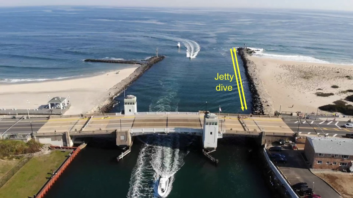
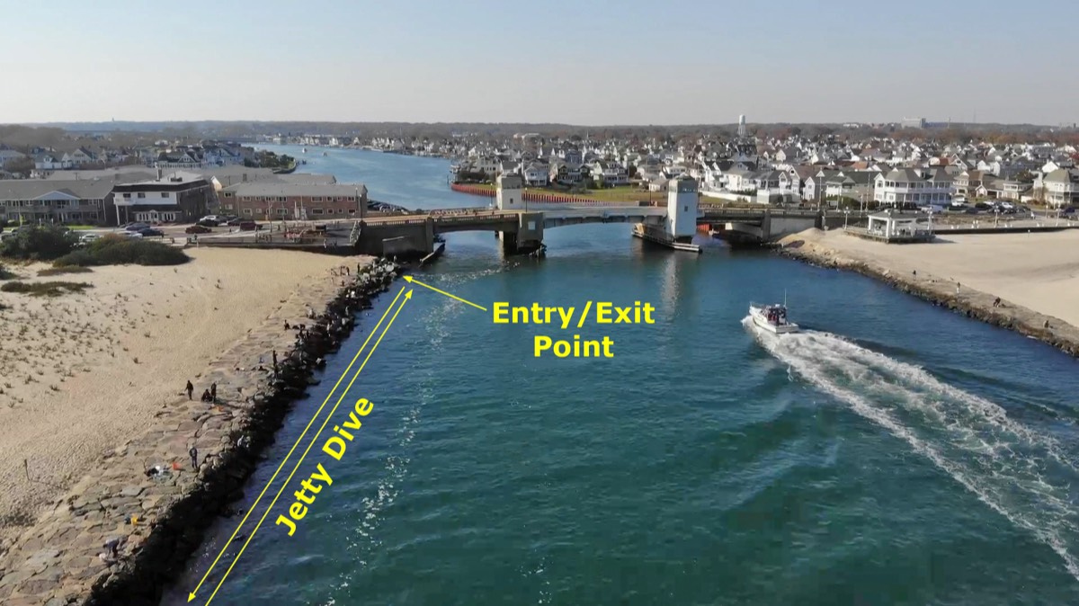
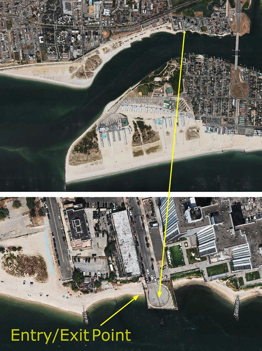
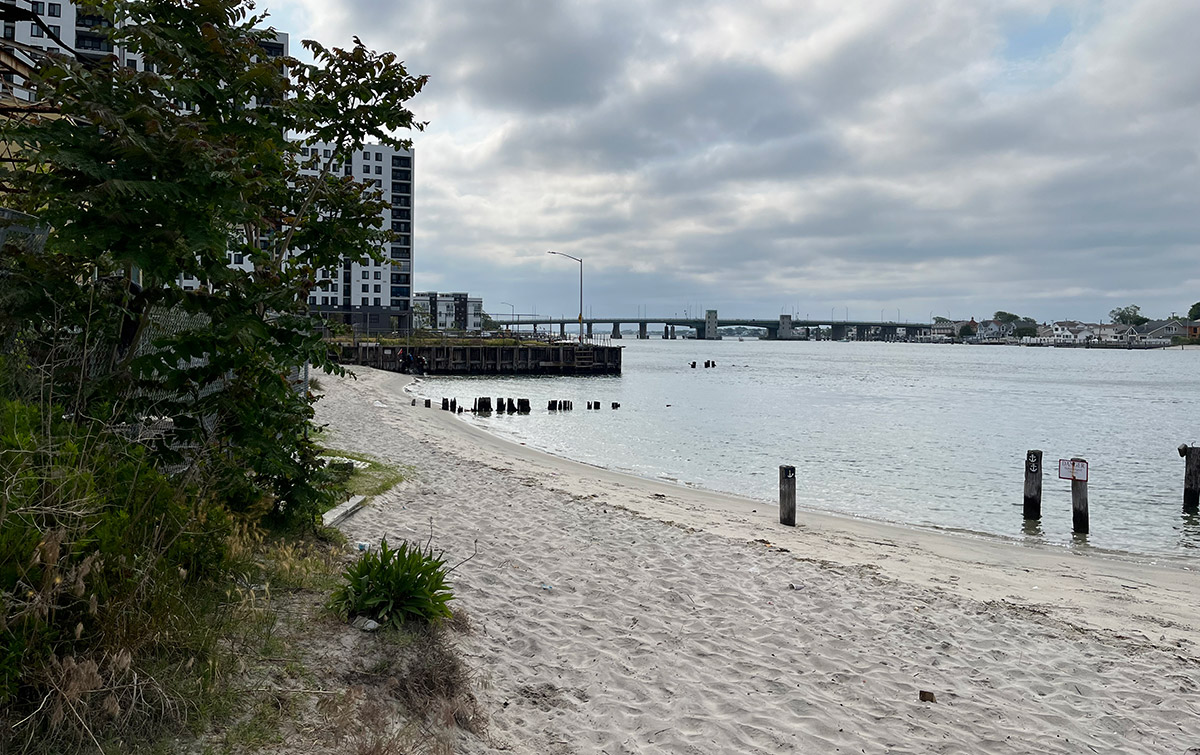
BEACH 8TH STREET
Beach 8th street in Far Rockaway has been one of the most popular dive spots in the NYC area for decades. Typical depths range from 5-25 ft but can go down to 40+ in the channel. Bottom composition is mostly sandy, with rocks from the jetties and the occasional park bench, tire or cinder blocks providing additional structure and habitat. Visibility averages in the 4-10 ft range, but in the late fall and early spring it is possible to have more than 20 feet. These clear days are particularly rewarding as there are some very impressive encrusting sponges and northern corals growing on the rocks in the channel that make this spot look almost tropical (almost).
Enter the water along the bulkhead on 8th street. The depth will quickly drop from about 5 ft to about 14 ft. Following the rock piles south will gradually bring you into deeper water and eventually the boat channel. This is where you will find some very impressive sponge and coral covered boulders. It is also where you will have the strongest currents. The area to the west is mostly sand bottom, although there are several old cages and a park bench that can be used for navigation. Diving the site should be done at high slack tide to maximize your chances for good visibility and to avoid heavy currents, especially near the channel. However the underwater jetties at 8th and 9th street provide a bit of protection from the worst of the current, and this is one of the more forgiving dive sites if you miss slack tide. Once you feel the current start to pick up, simply swim north to get back to the beach.
Unfortunately the biggest drawback to this site is the parking situation. While there is some street parking available near 8th and 9th Streets, these spots fill up quickly, especially in the summer when divers and fishermen flock to the site.
If you are willing to put up with the traffic and the parking you will find that this site is a fantastic spot for marine life. This site is a great place to find Blackfish, black sea bass, fluke, oyster toadfish, blennies, and even Lobsters. Due to the proximity of the inlet you really never know what the currents are going to sweep in including tropical fish, skates and dogfish, on rare occasions Octopus have been spotted here as well.
Lastly it's crucial to be aware that there are many fishermen and boaters in the area. Make sure to bring a dive flag and a dive knife with you. Unfortunately, there is a lot of monofilament here, and it's easy to get snagged if you're not careful.
SHORE DIVING VIDEO
Here is a little "sizzle reel" about the diving at the Manasquan River Railroad Bridge in Point Pleasant, New Jersey.
Here is a little "sizzle reel" about the diving at the Manasquan River Railroad Bridge in Point Pleasant, New Jersey.
This website is meant to help divers who are new to diving in the New York City area to become familiar with the specific practices, culture, gear and conditions commonly encountered here. It is NOT meant to be a substitute for formal training and certification with an appropriate instructor and agency. Every diver is responsible for their own equipment, dive planning and safety.